
Recorded presentations of the SDB Day 2021 in alphabetical order of the speakers’ names. You can directly access each presentation by playing the video. Presentation slides will be available soon.
CMDR Chris Waterson, Royal Australian Navy

By loading the video, you agree to YouTube's privacy policy.
Learn more
Keynote: Four years of SDB: A user’s perspective
CMDR Chris Waterson, RAN, is a specialist Hydrographic Surveyor in the Royal Australian Navy. He commanded the Survey Motor Launch HMAS Shepparton in 2008-2009 and the Hydrographic Survey Ships HMAS Leeuwin and HMAS Melville 2013-2015. In 2016, he was awarded certification as a Level 1 Hydrographic Surveyor through the Surveying and Spatial Sciences Institute and commenced working at the Australian Hydrographic Office where he was responsible for planning and managing national hydrographic surveys. He helped to establish and implement Australia’s national civil survey scheme, the Hydroshceme Industry Partnership Program, and was the AHO representative to AusSeabed, the national seabed mapping coordination program. In 2019, he moved to the Maritime Geospatial Program within the AHO where he oversaw the acquisition and introduction into service of the AHO’s Satellite Derived Bathymetry capability.
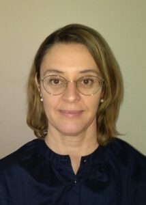
Captain Yanuar Handwiono, Indonesian Naval Hydrographic and Oceanographic Center
By loading the video, you agree to YouTube's privacy policy.
Learn more
Keynote: Satellite Derived Bathymetry Application for National Hydrographic Survey
Captain Yanuar Handwiono is a specialist Hydrographic Surveyor in the Indonesian Naval Hydrographic and Oceanographic Center. He begins his career as a hydrographic officer on a naval hydrographic survey vessel since 1988. He has been undertaken various professional courses in hydrography since then, He awarded Cat “A” surveyor at 1999 and commenced working at Indonesian Naval Hydrographic and Oceanographic Center where he was responsible for International Cooperation and Maritime Boundaries. He is also member of Indonesia’s maritime boundaries delegation expert and participated actively in many IHO events, working group and capacity building program. He contributed greatly to the establishment of the Indonesian Marine Spatial Data Infrastructure known as IMAGIC portal and optimizing the use of Remote Sensing Technology such as Satellite Imagery implementation in supporting hydrographic survey operations, disaster mitigation, and marine protection area mapping. In 2018, He involved with the Satellite-Derived Bathymetry implementation in the Indonesian Naval Hydrographic and Oceanographic Center as part of IMAGIC marine geospatial capability program development.
Edward Albada, EOMAP USA Inc.
By loading the video, you agree to YouTube's privacy policy.
Learn more
SDB Day 2021: Americas/Caribbean/Europe – Welcome and Introduction
By loading the video, you agree to YouTube's privacy policy.
Learn more
Introduction to SDB tools
Edward Albada represents EOMAP throughout the North Americas and Caribbean region. Edward is from Trinidad & Tobago and was introduced to the tropical clear waters of the Caribbean from birth. His love of the sea led him to pursue an education in Coastal and Oceanographic Engineering at the University of Florida. He has amassed 25 years of experience working on coastal development from inception, modelling, design and construction throughout the globe, with particular experience in projects within the Caribbean. Edward was first introduced to EOMAP in 2015, and has applied satellite derived services to almost every applicable project since. It transformed his approach to data and information gathering for his projects, in particular in uncharted, remote or inaccessible locations. Edward is based in Santa Barbara, California.
Christian Bödinger, EOMAP Germany
By loading the video, you agree to YouTube's privacy policy.
Learn more
Hands-On Watcor-X: the physics based SDB desktop software
Christian Bödinger is an Remote Sensing specialist with advanced knowledge and experience in satellite imagery applications, data analysis and workflow automation. At EOMAP since 2018, he works as an EO Data Analyst within a number of commercial and R&D projects around the globe. Supported by a team of physicists and IT experts, he is responsible for the implementation, development and supervision of WATCOR-X software. He has provided training on WATCOR-X globally and serves as point of contact for technical and related matters. He holds a MSc degree in Geography from the University of Tübingen.
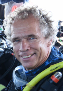
Stuart Caie, Land Information New Zealand (LINZ)
By loading the video, you agree to YouTube's privacy policy.
Learn more
LINZ SDB experience: charting SDB data
After 16 years working as a Hydrographic Surveyor in the UK, Stuart Caie moved to New Zealand in 2005 and joined Land Information New Zealand (LINZ) in May 2006 as a Senior Hydrographic Surveyor within the New Zealand Hydrographic Authority. Stuart lead the New Zealand Hydrographic Risk Assessment project, an evidenced based, risk lead assessment to prioritise future hydrographic surveys around New Zealand. The subsequent long-term prioritised survey programme, HYPLAN, was published in 2017. Stuart has responsibility for maintaining this programme of work which is delivered by a panel of two survey companies. Stuart is also working on a NZ Aid programme, the Pacific Regional Navigation Initiative, which is focusing on navigation-safety aspects in the South West Pacific, where LINZ is the charting authority responsible for producing and maintaining charts for the Cook Islands, Niue, Samoa, Tokelau and Tonga.
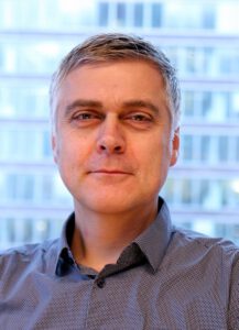
Dr. Knut Hartmann, COO EOMAP Germany
By loading the video, you agree to YouTube's privacy policy.
Learn more
4S, the European initiative to foster SDB and satellite-derived seafloor mapping
By loading the video, you agree to YouTube's privacy policy.
Learn more
Establishing independent SDB capabilities: tools and software
Dr. Knut Hartmann is passionate Earth Observation geodata expert and in the position of chief operating officer at EOMAP. Knut holds a degree in Geoecology and PhD in natural science. Prior to joining EOMAP in 2011, he worked in the geo-information section of an engineering company, as well as the German Federal Research Center. Throughout his career he has developed and applied solution for different applications and across a range of industries. Amongst others, he was expert advisor to an International Law of the Sea (ITLOS) court case, supports national benthic monitoring concepts on national levels and is leading the European innovation action to improve shallow water mapping. Since joining EOMAP he has been involved in various projects ranging from the higher latitudes of Greenland down to the southern Pacific.
Dr. Thomas Heege, Managing Director EOMAP Germany
By loading the video, you agree to YouTube's privacy policy.
Learn more
Improving autonomy of SDB measurements by physics-based multi-scene processing
Dr. Thomas Heege, managing director of the EOMAP headquarters in Germany, has more than 25 years of experience in aquatic remote sensing and environmental data services for marine industries and water-related agencies worldwide. Under his lead, EOMAP developed the technologies and the market for space-based high-resolution bathymetry, shallow water and water quality services. Prior to founding EOMAP in 2006, Thomas was research scientist and project manager at the German Aerospace Center DLR since 1996, developing physics-based processors for aquatic systems using multi- and hyperspectral airborne sensors. From 1993, he worked as researcher at hydrological/limnological institutes in Konstanz and Munich, in a wide range of multi-disciplinary projects with applied bio-optics and remote sensing mapping applications. He graduated as Physicist in 1993 at the University of Konstanz, and received the PhD in space sciences in 2000 at the Free University of Berlin.
Sophie Loyer, French Hydrographic Office
By loading the video, you agree to YouTube's privacy policy.
Learn more
SDB: hydrographic requirements in light of the latest technological progress
Sophie Loyer is an engineer for the French Hydrographic Office. Since the beginning of 2017, she’s a project manager in the department of R&D, with the SDB and decision support tools as the main topics. Before, she was in charge of acoustic multibeam data processing and early in her carrier, she was coastal and marine ecosystem research scientist.
Friedhelm Moggert-Kägeler, SevenCs
By loading the video, you agree to YouTube's privacy policy.
Learn more
Detecting Hidden Shoals from Space
Friedhelm Moggert-Kägeler‘s educational background is Geodesy/Hydrography and he holds a degree in each of these fields. He joined SevenCs in 2000. Since then, his variety of roles has ranged from S-57 data production and training, customer support, and research and development, to product management. Now his responsibility is to develop strategies and solutions for products and services used to manage, analyze, and distribute Maritime Spatial Data. Through long-term experience, Friedhelm has specialized expertise in the domain of electronic chart production and also in-depth knowledge of relevant IHO standards. He regularly represents SevenCs at IHO working group meetings, industry conferences and exhibitions.
Dr. Chris Roelfsema, University of Queensland
By loading the video, you agree to YouTube's privacy policy.
Learn more
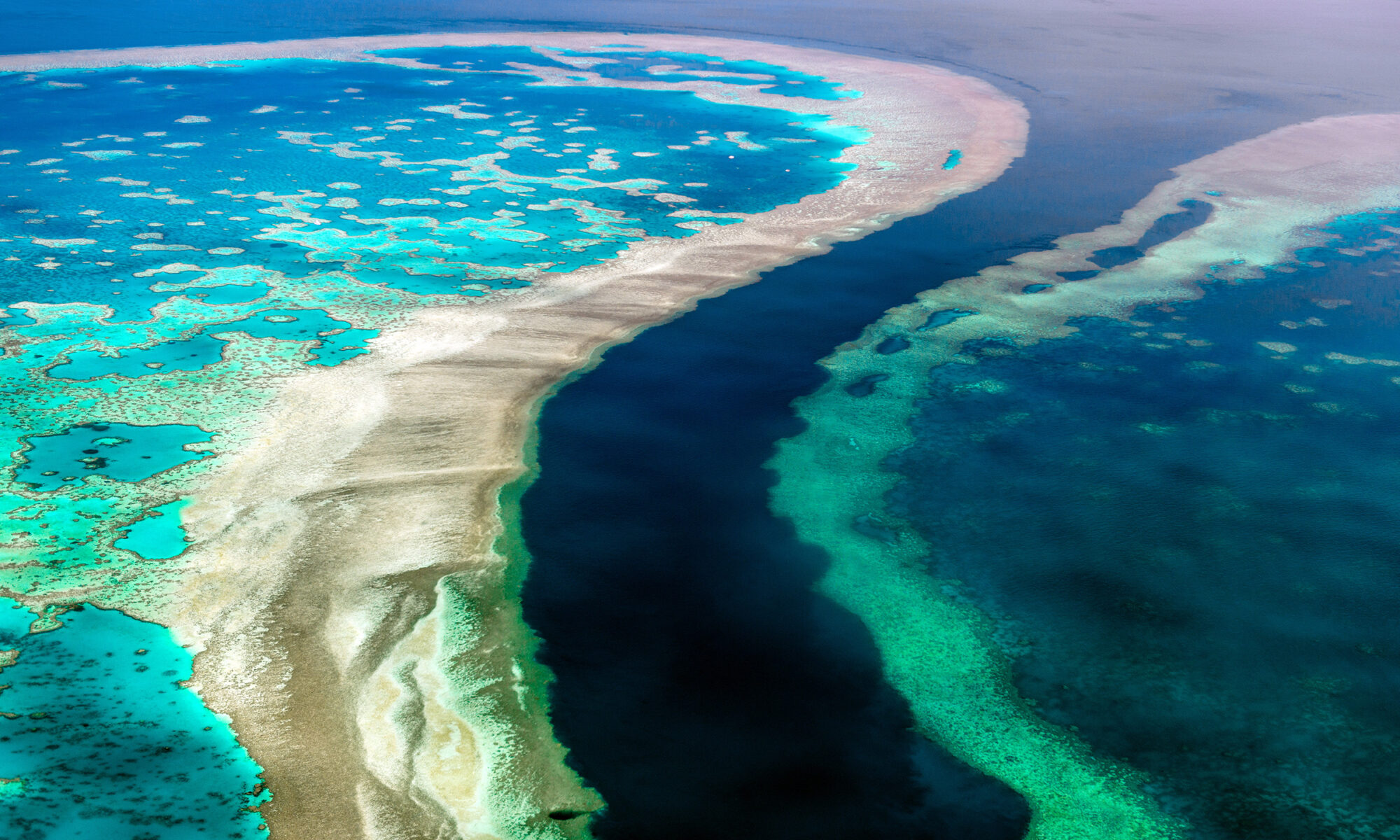
How much Coral Habitat is there on the Great Barrier Reef, and why is depth so important?
Dr. Chris Roelfsema is a senior research fellow at University of Queensland and leads a team of ecologists and earth observation specialists with collecting field data and developing and implementing habitat mapping and monitoring approach. With 20 years of experience he is specialised in integrating field data, citizen science, physical attributes (e.g. depth, waves) and earth observation science to map and monitor coral reef and seagrass habitats globally. Chris is currently the principal investigator on two major coral reef habitat mapping projects: 1) 3D GBR Habitat Mapping project; and 2) Global Coral Reef Mapping project for the Allen Coral Atlas.
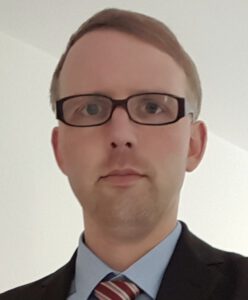
Stephen Rump, FUGRO Germany
By loading the video, you agree to YouTube's privacy policy.
Learn more
Close the gap: SDB for pre-installation cable route surveys
Stephen Rump is a geomatics engineer with over 14 years of professional experience in hydrographic processing. He is leading the hydrographic processing and cable route charting department at Fugro Germany Marine and is responsible for the preparation and quality control of corresponding data and charts including SDB products.
Dr. Richard P. Stumpf, NOAA
By loading the video, you agree to YouTube's privacy policy.
Learn more
A potential future for SDB: addressing turbidity, scene selection, and labor
Dr. Richard P. Stumpf, Oceanographer, NOAA National Ocean Service, National Centers for Coastal Ocean Science
Dr. Stumpf has over thirty years of experience in coastal oceanography. He develops methods to make satellite data and modeling useful in understanding and managing coastal eutrophication, habitat change, shallow bathymetry, and algal bloom forecasting. He received a B.A. degree in the Environmental Sciences from the University of Virginia, and M.S. and Ph.D. degrees in Marine Studies from the University of Delaware
Emily Twiggs, Project Manager EOMAP Australia Pty Ldt.
By loading the video, you agree to YouTube's privacy policy.
Learn more
SDB use cases in the Oceania Region
Emily Twiggs is a geoscientist that represents EOMAP throughout the Australasia region. Originally from England, Emily moved to Australia 20 years ago after completing her degree in Geological Sciences. During her time travelling around Australia, Emily became a divemaster and whale shark spotter on the Ningaloo Reef, an experience which cemented her love for the ocean and marine science. For the last 15 years, Emily has gained a broad range of experience during her PhD research and work life (Curtin University, Australian Institute of Marine Science and Fugro Airborne Surveys), in using remote sensing and geospatial analysis alongside ground-truthing techniques, to map the bathymetry, geomorphology, sedimentology and benthic habitats of coastal, coral reef, continental shelf and terrestrial environments. As Director for Oceanwise Australia, she also ran research-based whale shark and coral reef ecotours, educational programs, and environmental services on the Ningaloo Coast World Heritage Area and elsewhere in Western Australia. For the last 2.5 years, Emily has worked as Senior Project Manager with EOMAP based in Perth (WA) and has been involved in many exciting mapping projects within the region.
Philip Warner, Managing Director Smith Warner International Ltd.
By loading the video, you agree to YouTube's privacy policy.
Learn more
Satellite derived information for coastal engineering and planning: Use cases from the Caribbean
Philip Warner has a Master’s degree in Coastal Engineering from Queen’s University, Canada and over 25 years of professional experience in consulting throughout the Caribbean and North America. He has design, inspection, and appraisal experience for coastal protection, marine structures and oceanographic studies, in addition to the development and operation of numerous civil, structural, coastal and hydraulic engineering computer programs and numerical models. He also has field experience in marine structures construction supervision and inspection, hydrographic surveys and the deployment of oceanographic field equipment. His experience includes work done throughout the Caribbean region and internationally.
Dr. Magnus Wettle, Managing Director EOMAP Australia Pty Ltd.
By loading the video, you agree to YouTube's privacy policy.
Learn more
SDB Day 2021: Asia/Oceania – Welcome
By loading the video, you agree to YouTube's privacy policy.
Learn more
The SDB Trajectory: History, Recent Showcases, and SDB 2.0
Dr. Magnus Wettle is Managing Director for EOMAP Australia. He has more than 17 years experience in aquatic remote sensing research and applied solutions. During his career at CSIRO, he co-developed the SAMBUCA software, which is used today by CSIRO for shallow water applications. While at Geoscience Australia, he led the implementation of new capabilities such as satellite-based bathymetry and offshore oil seep detection. As a Senior Research Fellow at the University of Queensland, he managed the delivery of multi-disciplinary, remote sensing-based solutions to the natural resource industry.